Supreme Beef – Floodway Obstruction
The Iowa Code (statutes) and the Iowa Administrative Code (rules) proscribe obstructing a FEMA floodway. The Code language was discussed in detail in “Facts about Iowa Code and Your Rights” but to repeat:
455B.275 Prohibited acts — powers of commission and executive director.
- A person shall not permit, erect, use, or maintain a structure, dam, obstruction, deposit, or excavation in or on a floodway or floodplains, which will adversely affect the efficiency of or unduly restrict the capacity of the floodway, or adversely affect the control, development, protection, allocation, or utilization of the water resources of the state, and the same are declared to be public nuisances.
The construction of the manure basin that now obstructs the floodway is a sordid story. It’s illegal for several reasons. However for the purposes of the water permit renewal challenge let’s consider how it “will adversely affect the…protection…of the water resources of the state”. The groundwater aquifer.
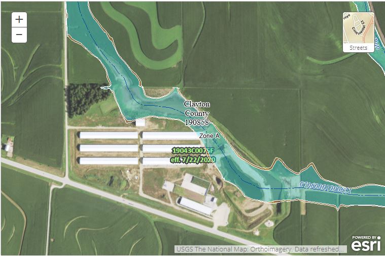
Shown below are two images. Click on the links to get a larger image. The first shows the FEMA floodway based upon contours from 2010 LIDAR. The ortho photo is from 2018, so it shows the barns completed, but the manure basin under construction. The intermittent stream centerline is in blue. Note that the earthen basin completely obstructs the floodway. This is exacerbated by the fill brought in to allow construction of the NE barn which also extends into the floodway. In the mid-upper left of the image, note a small blue protrusion of the floodway leading into the triangular wooded area. The wooded area NW of the barns contains five known sinkholes! The second image includes a 2021 ortho that shows the basin completed, superimposed upon a color-mapped contour plot, again based upon 2010 LIDAR.

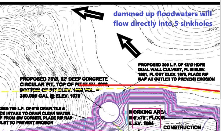
View the enlarged image carefully. The contours and the colors will help you visualize where the floodwaters waters dammed up by the obstruction are likely to go… directly into the sinkholes. Directly into the groundwater aquifer. Visualize the new path the obstructed waters are likely to take as they sweep along the entire NE face of the earthen basin.
This situation presents three concerns related to “protection… of the water resources of the state”:
The basin completely obstructs the existing floodway, and will act as a partial dam. This is exacerbated by the construction fill that was necessary to raise and construct the NE barn. As the floodway elevation rises, the amount of floodwaters going directly into the five known sinkholes will increase enormously. That’s pollution of groundwater.
The new elevated floodway will sweep completely along the NE face of the earthen basin; I suspect this could be modelled using “streambank erosion” programs. This could lead to catastrophic failure of the manure basin walls. The contents will spill into the sinkholes or will be washed directly into Bloody Run Creek. That’s pollution of “waters of the state”.
The hydrostatic pressures in and under the basin could be enormous. Great enough to compromise the “clay” base of the basin, and rupture the polyliner that is on top of the “clay” base. I put “clay” in quotation marks because we do not know if they paid to bring in high quality clay for the base, or simply compacted the excavated fill that had a clay component and called it good. We do know that the basin is directly over karst because they used dynamite during the pit excavation. We also know from a failed well drilling log that there is a cavernous void, at least eight feet high, under parts of the site.
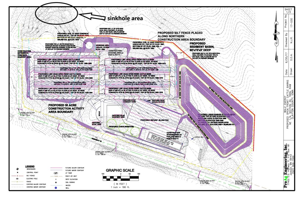
For the engineers among you, here are three drawings derived from the Stormwater Pollution Prevention Plan (SWPPP) to help better visualize the enormity of the problem. Click on the links to get the larger images.