These maps and graphs are available to use in public comments expressing your personalized concerns.
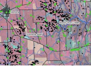
This map shows known sinkholes and the location of private household and livestock wells. The manure application fields in the area listed by Supreme Beef LLC in their nutrient management plan are also shown. Click here to view the complete map.
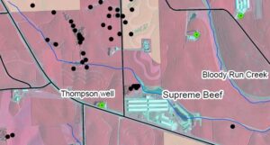
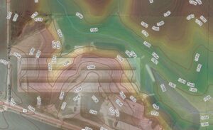
This closeup shows the five known sinkholes located 350 feet north of the cattle containment structures, and adjacent to the natural floodway of an intermittent stream flowing to Bloody Run Creek. The barns and the earthen basin will greatly increase the amount of floodwater entering the sinkholes and polluting the aquifer.
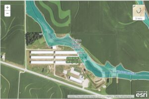
The official USGS-calculated drainage area at the point of obstruction is 2.4 square miles. All of that floodwater is now partially obstructed by the SB structures. Much of it will back up into the sinkholes. The new flow path will sweep along the NE face of the earthen berm, possibly leading to erosion and the collapse of the earthen manure structure during an extreme rain event.Click here to see the complete map.
This map shows the USGS-calculated FEMA floodway naturally flowing through the exact location of the 39-million gallon earthen manure basin. This is a Zone A floodway. Floodplain construction regulations may or may not apply. That’s not the issue. This map is intended to show the RISK to groundwater posed by the obstruction of the floodway. That’s what the Water Permit folks are tasked with considering. Click here to see the complete map
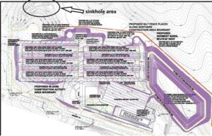
Sinkholes are less than 300 feet from the cattle buildings. The threat to the aquifer from polluted runoff or during stormwater events could not be clearer. Look carefully at the contour lines. The earthen basin almost completely obstructs the floodway. This drawing is from the construction plan submitted by the applicant to the DNR wastewater and stormwater groups in 2017. Click here to see the complete drawing.
Finally, this is the 2010 color-hillshade map with contour lines with the 2021 image of Supreme Beef superimposed. On the expanded view the risks of damming floodwater into the sinkholes and erosion of the NE face of the earthen basin during heavy rain events is evident. Less evident is that as the water table rises beneath the basin floor during flood events, the pressure exerted could erode the earthen base and rupture the plastic liner. That’s the worry expressed by the liner manufacturer! Click here to see the complete image.
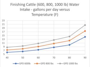
The applicant still claims his cattle will only need 6.0 gallons/day/head. Water consumption by cows is not a secret! These graphs were created from data vetted by the university Extension Services of Iowa, Nebraska, and Oklahoma. The average annual use will be greater than 10.0 gallons per day per head, with peak summertime use possibly exceeding 20 gallons per day per head. That means annual water withdrawal exceeding 42 MGY, not the 22 MGY claimed.Click here to see the complete graph.
There are 14 known AFO’s (animal feeding operations) within a 5-mile radius of Supreme Beef LLC. Each cross indicates a known sinkhole. There are five sinkholes ~300 feet from the Supreme Beef site, hidden behind the yellow pointers. Supreme Beef will increase the manure produced in the area by a factor of x3.8 – 380%!! A lot of that manure will be spread on USDA designated highly-erodible-land within that 5-mile radius. Click here to see the complete image.
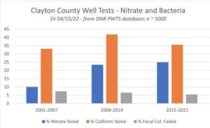
Clayton county well tests over the past twenty years show contamination by coliform and fecal coliform bacteria, as well as nitrate levels exceeding the 10ppm advisory threshold. Data allowing a comparison of contamination with well depth exists but was not readily available. A more granular comparison of monthly well tests vs monthly rainfall events may also be possible. Bottom line… Wisconsin studies link Driftless Area well contamination to manure-polluted surface runoff and infiltration.Click here to see the complete image.
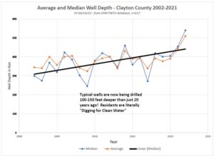
Wells are now being drilled more than 100 feet deeper than just 20 years ago, at considerable cost. Clayton County residents are literally “Digging for Clean Water” as wells in shallower aquifers become contaminated. In their official groundwater reports, DNR lists this area as “highly vulnerable.” How does it benefit the publics health or welfare to allow animal production facilities to grow so large they have no place to safely dispose of their manure without polluting surface and groundwater?Click here to see the complete image.
One-third of all active household and livestock wells in Clayton County are less than 200 feet deep. More than two-thirds are drilled to less than 300 feet. These wells can extremely vulnerable to contamination from surface infiltration of pollutants into the aquifer. Not everyone can afford to drill wells 600 feet deep. The problem is not going away soon. Click here to see the complete image then…