Wells in Clayton County by Depth and Vulnerability
The wells in Clayton County draw from several aquifers, some shallow and some deep. The typical well drilled today is 100-150 feet deeper than wells drilled 20 years ado. Shallow wells are more polluted with nitrate and bacteria. Everyone knows it. The karst region of NE Iowa is recognized by DNR as the most vulnerable area in the state.
Clayton County residents are literally “digging for clean water”.
In addition to presenting Iowa Geologic Survey Bureau GEOSAM data for wells in Clayton County, we also used Private Well Tracking Service (PWTS) data, managed by the DNR, to show the level of contamination measured in 94 private wells within a five-mile radius of Supreme Beef LLC.

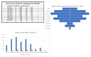
Well depths for more than 1000 private household and livestock wells in the GEOSAM database were grouped and plotted by well depth. Note that county-wide more than 25% of wells listed in GEOSAM are less than 200 feet deep. More than 67% are less than 300 feet deep. After creating this chart we looked at PWTS listed wells and the percentage of shallow wells was even greater! These wells are subject to pollution from surface water infiltration and water entering sinkholes. Click here to view the full image.

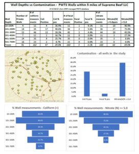
We used DNR’s Facility Explorer to locate 94 private wells within a five-mile radius of Supreme Beef LLC. The well identifiers allowed us to use the PWTS database to obtain information about well depth and well testing results since 2000.
Well depth groups were plotted against well test results for coliform, fecal coliform, and nitrate. We used 5.0 ppm as the threshold for nitrate. This is reasonable and defensible from a public health standpoint. The outdated “safe drinking water ” standard of 10 ppm, was not plotted. See the scientific articles related to well contamination and public health. Click here to view the full image.